Aechelon Exhibits at GEOINT Symposium 2026 to Enable Civilian and Defense Partnerships Using Synthetic Reality
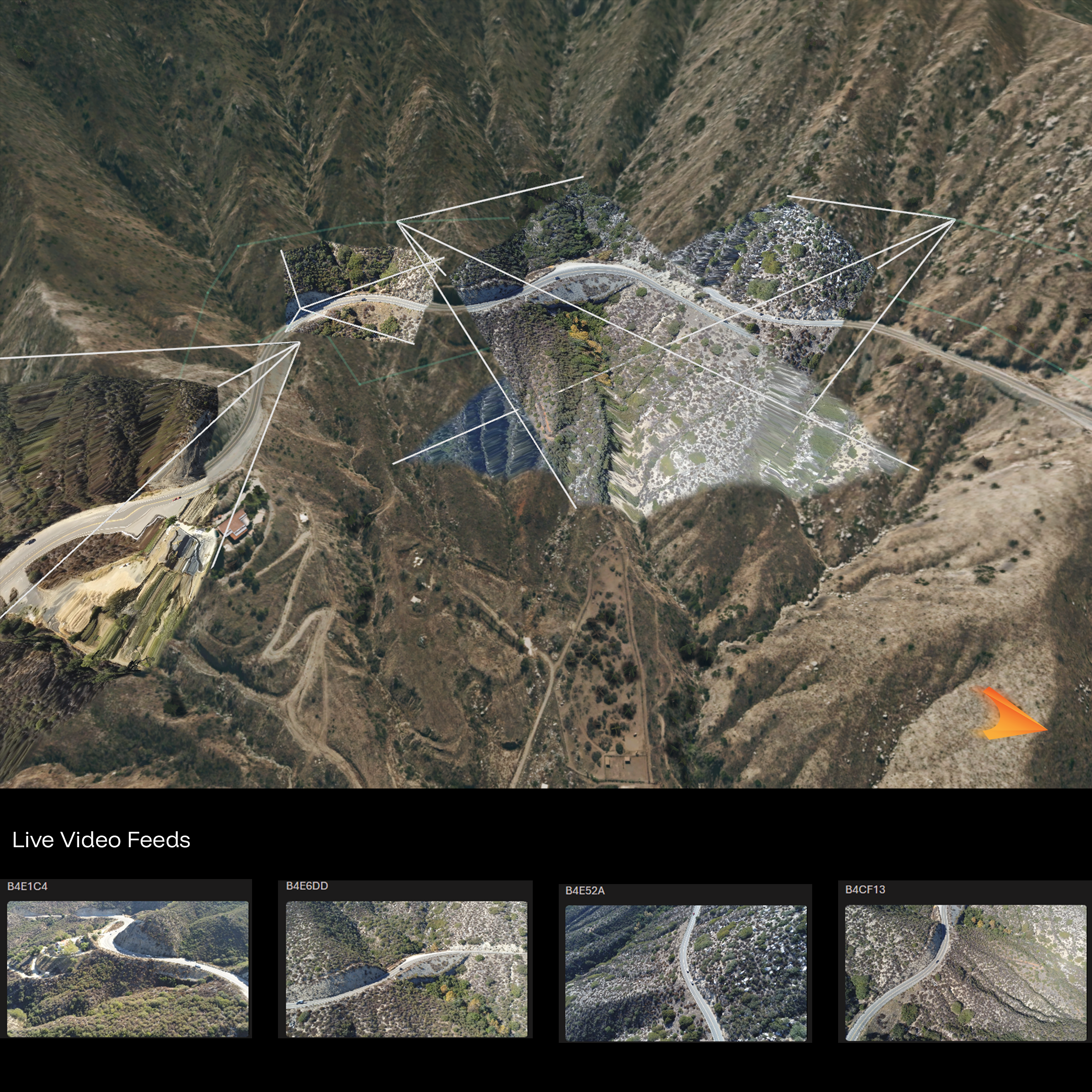
Aechelon’s GPU/CUDA technology reprojects multiple live drone video feeds into real-world 3S space in real-time, achieving less than one millisecond of processing per stream. This gives human operators full situational awareness and a clear understanding of both current and past events.
May 4, 2026 – GEOINT Symposium, Aurora, CO Booth 2205 – Aechelon Technology, Inc. (South San Francisco, CA) (“Aechelon”), the leading provider of advanced geospatial and visual simulation solutions, today announced it is expanding its presence within the ISR and geospatial intelligence community at the acclaimed GEOINT Symposium. With a stated goal of reaching out to the entire ecosystem enabling AI and ML integration pipelines from sensor providers and platform developers to integrators and end users, Aechelon is showcasing a wide range of its platforms, solutions and partnerships specific to this mission-critical market.
Introducing Aechelon to the ISR Community
Aechelon is the leading provider of advanced 3D visualization solutions using real-time Synthetic Reality as well as high-fidelity 3D geospatial terrain data, delivering mission-ready global 3D terrain for operational environments where precision and reliability are non-negotiable. The company’s orthorectified 3D terrain datasets provide globally consistent, high-accuracy whole-Earth coverage, including detailed material code attribution to support realistic and relevant all-sensor representations.
Earth’s Digital Twin: Project Orbion
Announced in September of 2025, Project Orbion reflects Aechelon’s shift toward composable data integration across both civilian and defense use-cases. Leading a coalition of Vantor, BlackSky, ICEYE, Distance, and Niantic Spatial and designed as the first-ever “digital twin” of the entire planet, Orbion enables ingestion, projection, and augmentation of diverse sensor inputs. These include EO/IR, LiDAR, RF/Radar-derived datasets, and other emerging modalities. This open approach to GEOINT emphasizes practical interoperability at both the rendering and analysis layer and aligns with Aechelon’s emphasis on broader partner ecosystems. Learn more at https://aechelon.com/project-orbion/.

Proven Infrastructure for IC and DoD Systems
Aechelon’s technology is built for direct integration into Intelligence Community and Department of Defense systems, supporting full-spectrum theater operations. The company has a long-standing track record delivering stable, high-performance image, sensor and data generation (IG) capabilities to U.S. government customers, including U.S. Department of Defense and Allies. In ISR contexts, visualization is not downstream—it is part of the decision loop. Aechelon’s systems are engineered accordingly, prioritizing determinism, stability, and performance under operational constraints.
Accelerating ISR and MCIS Workflows
Aechelon enables accelerated ISR and Mission Command Information System (MCIS) workflows by providing a real time, interactive 3D representation of the battlespace in support of C5ISR systems accelerating data update rates to leverage commercial LEO asset constellations. The platform supports multiple real time ISR video stream visualization in context for use within integrated surveillance, reconnaissance, and mission command environments—reducing latency between collection, processing, and visualization.
The Community Has Spoken
“The recent announcement of Project Orbion by defense simulation leader Aechelon Technology and a consortium of specialized partners marks a pivotal moment in the evolution of geospatial intelligence and digital twin technology. This initiative represents a profoundly ambitious endeavor: to create a live, AI-enabled, planetary-scale digital twin of Earth, rendered in what Aechelon terms “Synthetic Reality” — Project Geospatial
“An industry team including space-based remote sensing providers and AI visualization specialists has unveiled a planetary-scale geospatial model that could serve as a live “digital twin” of the Earth, dubbed Project Orbion. The platform combines real-time satellite imagery, radar intelligence, video photogrammetry and AI-enabled data visualization to help potential customers monitor wildfires and floods, or track troop movements and shipping routes.” — Aviation Week
About Aechelon
Aechelon is a global leader in simulation and training systems, specializing in geo-specific flight simulators and physics-based sensor AI training. Aechelon’s cutting-edge Synthetic Reality (SR) platform replicates real-world environments with unmatched realism, enabling both humans and machines to operate effectively in complex, detail-rich environments. This technology allows pilots and emergency responders to train for complex, high-stakes situations in immersive, ultra-realistic virtual settings.
Developed for the most demanding training, simulation and analysis missions, Aechelon’s Synthetic Reality has been the trusted tactical simulation choice of militaries throughout the free world for decades and now brings the same trusted architecture to civilian applications. Aechelon Technology is a Sagewind Capital platform company – please visit www.aechelon.com for more information.