
Sunnyvale, CA (11/24/2000) Aechelon Technology Announces Expanded Geographic Coverage
|
 |
|||||||||||||||||||||||||||||
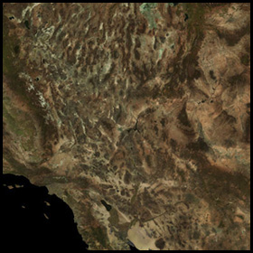
| Aechelon Technology’s stock database includes over 1,000,000 square kilometers or 422,000 square nautical miles of the southwestern United States. The database area covers from 31 28 54N to 40 40 4N latitude, and from 108 30 21W to 120.28.31W longitude. | |||||||||
 |
Base out-the-window coverage is derived from 6-band satellite data, composited into a true color mosaic. More than one tenth of the database is comprised of 4m satellite data, covering all tactical range areas and buffering key airfields outside of these range areas.
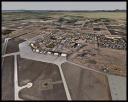
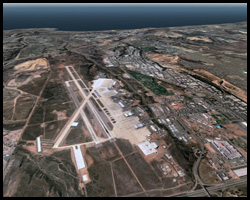
Over 40 high resolution aerial insets are available, varying in resolution from .5 meters per pixel to 2 meters per pixel. High resolution aerial coverage for the major metropolitan areas of Phoenix, AZ, Las Vegas, NV, and San Diego, CA, is also available. |
||||||||
The following airfields are included in the stock database at high resolution (.5m to 2m pixel resolution) :
|
|||||||||
| US Tactical Range areas at 4m resolution include the Nellis ranges (4807, 4808, 4806), as well as Ranges 2308A, 2306A, 2306B, 2507N, 2507S, 2508, 2505 and 2524. The Barry M Goldwater Range (2301W, 2301E, 2304) is available at 4m resolution with specific range areas at 1m and 2m resolution.
The entire database area includes a correlated materials map at a base resolution of 26m for use in C-Radiant and C-RADAR. The classification includes over 40 individual material types and is modulated with the visual out-the-window data to provide the industry standard in sensor-based simulation. |
 |
||||||||